
Monitoring Malleefowl Mounds (where adults go on treasure hunts for giant sandcastles)
/
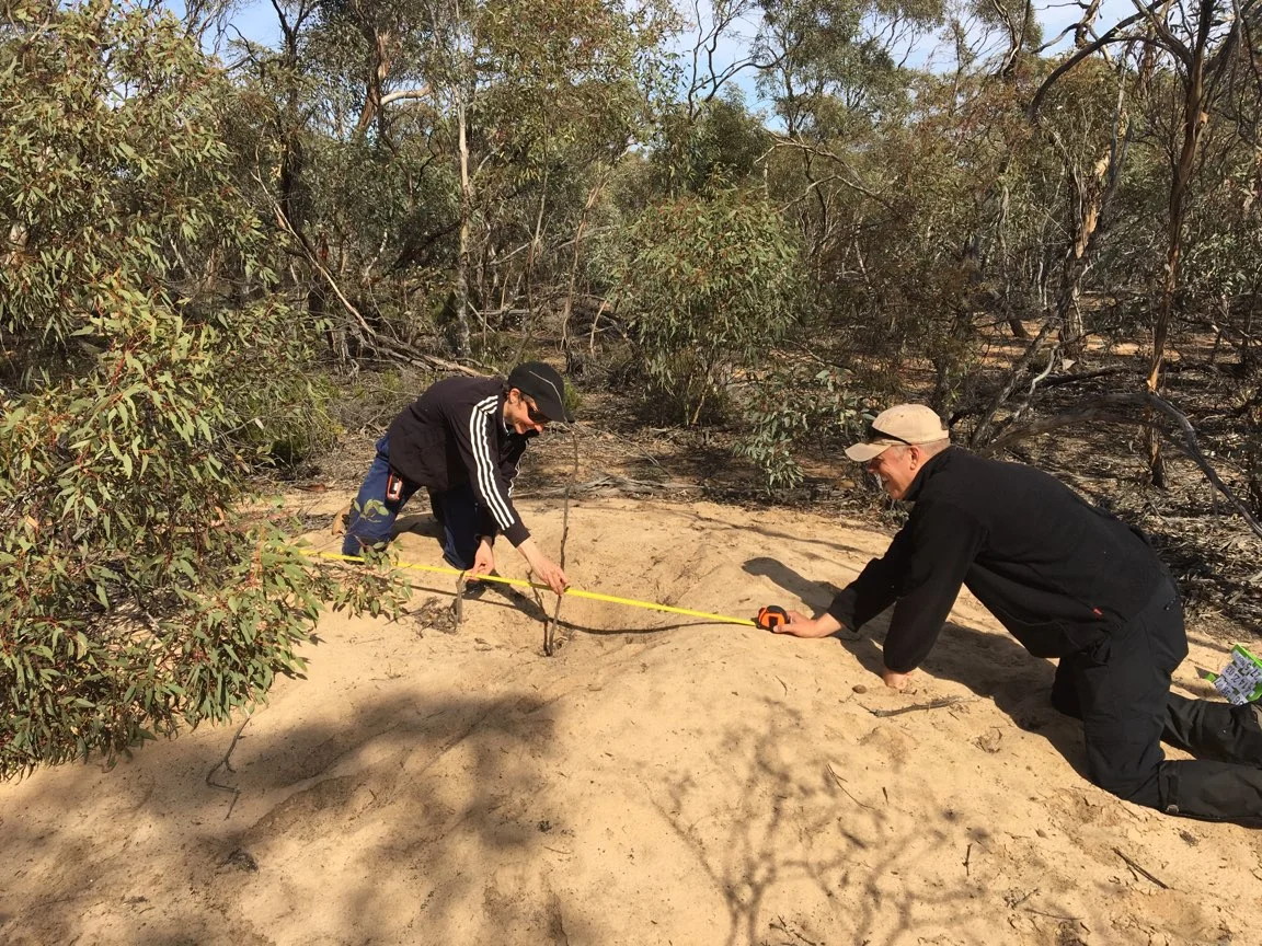
Myself, Kent and Michael (left to right) investigating tracks and scat on a Malleefowl mound. Photo: Tanya Loos.
After witnessing regular sightings of Malleefowl on our bush block and then finding an old, inactive mound, Michael and I were ridiculously excited to join the group of volunteers who monitor the nesting activity of these fascinating birds. Each year the Victorian Malleefowl Recovery Group (VMRG) hold a weekend workshop to bring the flock of volunteers together, learn about the latest research and train newbies like us.
Held at Wonga Campground in Wyperfeld National Park, the training weekend was a buzzing social event that attracted people from all over the state. John Olsen, VMRG President, warmly welcomed the crowd and acknowledged the efforts of the many people who are essential to keeping the group running smoothly and organising a successful training weekend.
The monitoring program started over 20 years ago in Victoria, powered by the dedication of citizen scientists who enjoy tromping around the bush, searching for clues left by the elusive “chooks” as one local affectionately referred to them as. The data that is collected is added to the National Database and is used to track trends in Malleefowl populations. Being listed as endangered in Victoria and vulnerable nationally, the ultimate aim of the 2007 Recovery Plan for this iconic species is to secure existing populations and get them de-listed within 20 years.
Dr Joe Benshemesh, the scientist who analyses the data, was an engaging and entertaining presenter, sharing the latest research and findings. In 1987 Joe started setting up monitoring sites and his obsession with these mysterious birds has only increased. Clearly his enthusiasm is infectious if this large group of volunteers is anything to go by!
That afternoon our group of newbies set out on a practise session where we learnt the safety protocol and became familiar with the monitoring equipment. Joe often commented on the consistent, high quality data collected by volunteers, so we were keen to uphold those standards and inspired to join a group that was so highly regarded. Over the next few days Michael joined experienced volunteers to hone those newly acquired skills, because in a few weeks we’d be monitoring on our own.

No datasheets here! The modern toolkit for these citizen scientists includes a GPS and an android phone with a customised app called CyberTracker. It makes monitoring a breeze!
We were allocated an area of Wathe Flora and Fauna Reserve and seeing as it’s only 20 minutes from our house, we decided to nip out in the late afternoon to do a quick hour of monitoring. I’d had a stressful day at work so I was looking forward to the distraction of being outdoors on a treasure hunt for giant sandcastles. Michael had packed the car and had answered “yes” to all my questions of “have you remembered this, where’s the GPS, did you pack the measuring tape” etc. I could feel the tension in my shoulders start to fade away as I put the car into 4WD for the sandy tracks coming up. The sand got deeper and I casually asked “have you got the recovery tracks?”. Michael went quiet, then said “Oooh, umm, no. We’ll be fine though. Take a left at this next track and get a bit of speed up!”
I gunned it up the rise but got bogged in the sand when I started to turn the corner. I reversed out of it, back down onto the flat area and tried again, but got stuck again in the same spot. We swapped drivers and Michael tried the same thing (but faster) and got stuck (deeper). The next half an hour was spent digging the sand out from around the wheels, laying down branches to reverse back on, and using our new toy, the air compressor, to let air out of the tyres to a consistent level. We finally got out and screamed a triumphant “woo hoo!!” to let the resident Malleefowls know. I was sweaty and covered in sand, but definitely not worrying about work now!
We used the last half an hour of light to monitor some mounds near the flat part of the track. Michael took the map and GPS, leading us close to the first mound. Then we scanned the bush around us and spotted a stake and metal tag. The number on the tag matched the mound we were seeking so I started recording details with the CyberTracker app that has been customised for monitoring Malleefowl mounds. The main tasks are:
Take a photo of the mound standing at the stake.
Judge the profile of the mound, which will also help to tell if it is active or inactive.
Carefully search the mound for pieces of broken eggshell, lerp, tracks and scats.
Measure the diameter, height and depth of the mound.
Leave two sticks crossed over in the middle of the mound as an indicator for next year’s monitoring. If the sticks are still in place then the mound is inactive. If a Malleefowl fancies renovating the mound, the sticks will be kicked out pronto!
Measuring the depth and rim diameter of the mound. Photo: Tanya Loos.
After doing a few mounds we got into a groove and became faster at assessing and recording the details. If fox scat is found on a mound there’s an additional task. It must be collected in a bag, then the details of the mound, date and person monitoring is written on a tag. It is hoped that this may be useful in future for research purposes.
As I bagged and tagged another fox scat, I took a moment to imagine what it must be like for the volunteer who receives all these bags in the mail. Delightful little express-post parcels of poo that they have to weigh, then enter against the details of the mound it was found on. How do they store it all? Are they running out of space? Will it get to the point of needing to rent a self-storage unit? Are you allowed to store copious amounts of poo in self-storage units??

A little baggy of fox poo, who wouldn’t look forward to receiving a few of these in the mail?
Our next day of monitoring was a breeze because two of our birding buddies, Kent and Tanya, had travelled up from Melbourne to help us and learn what was involved. As we casually wandered through the bush, relying on the GPS to lead us to each mound, it dawned on me that the passionate volunteers who had started monitoring over 20 years ago wouldn’t have had these luxuries. I couldn’t imagine the hours it would have taken to systematically scour the bush to accurately record all the mounds.
I was intrigued to learn how it was done in the early days, so I spoke to Ron and Gwyn Wiseman who used to do all the monitoring in Wathe and know it inside and out. “We used a grid system and a compass. The baseline is marked at 200 metres and the gridlines are marked with red reflectors on metal posts every 50 metres away from the baseline. For instance, to reach one mound we’d walk 900 metres from the baseline, then walk 30 metres from the gridline at a bearing of 245 degrees. This was mostly done by counting your steps. After we found the mound and recorded the details, we’d retrace our steps back to the baseline and make our way to the next mound.”
I asked Ron what difference it made once GPS’s were used. “It easily halved the time it took to monitor, it was brilliant! And we discovered new mounds more often because we didn’t have to backtrack to the baseline every time, we were covering new ground as we walked from one mound to the next.”
Gwyn’s wonderful collection of photos, stories, articles and publications about Malleefowl have the makings of a future museum! She kindly lent me a lot of this material and I thoroughly enjoyed flicking through it over a cup of tea. However the photos of a fox taking eggs and chicks from a mound were not pleasant and motion detection cameras remain a valuable tool when monitoring the impacts that other animals have on Malleefowl.

This fox had a good feed, taking this egg after already pinching a chick an hour earlier. Photo: Ron and Gwyn Wiseman.
This treasure trove of information made me wonder, what is it about Malleefowl that captivates so many people? Ron is fascinated by their strange nesting habits. “This bird spends hours and hours digging a mound, testing the temperature and keeping it at 33 degrees for perfect incubation. Then as soon as a chick hatches and digs its way to the surface, the parents don’t give it a second look, they usually ignore it or sometimes attack it!”
Gwyn commented that “People just wouldn’t believe you when you told them about Malleefowl, because so many people have never seen one. It takes patience and local knowledge to find them.”
I should probably ask myself the same question, seeing as I’m planning a monitoring trip on Sunday and will have to start quite early because it’s going to be hot!
This evocative poem, “To a Megapode” penned by Terri Gitsham Allen, beautifully captures the nature of Malleefowl and their surrounding environment. Perhaps it is seeing the relentless determination of the Malleefowl that fuels the endurance and curiosity of volunteers.

By Louise Nicholas.
Note:
If you’re interested in learning more about monitoring Malleefowl mounds or becoming a volunteer check out this video and the Victorian Malleefowl Recovery Group’s website.
Thanks to:
Ron and Gwyn Wiseman - for sharing your stories and memorabilia with me.
Terri Gitsham Allen - for allowing me to share your beautiful poem.
Victorian Malleefowl Recovery Group – for running such a tight ship and making new members feel welcome and supported.
Tanya and Kent – for helping us monitor in Wathe and taking photos of us in action.
Michael Gooch - for putting up with my high-pitched squealing on most 4WD missions!